Maureen Williams, 82, of Westgate, recalled a school trip into the rumoured tunnels under Chichester when she was at Chichester High School for Girls.
She estimates she was in her early teens at the time and said she chose to share her memories after reading about the search for evidence in this newspaper.', '
One of the most common questions I’m asked about Peterborough’s history is whether there are any tunnels under the city. Local legends say that there is a tunnel stretching from the Cathedral to Monk’s Cave at Longthorpe. Similar tunnels are alleged to stretch from the Cathedral to the abbeys at Thorney or Crowland.
These are familiar myths in many historic cities across the UK, mostly urban legends based on half remembrances of sewers, cellars or crawlspaces, coupled with wishful thinking and rumour.
Historically, to build a house with a simple cellar you would dig out the ground to a depth of around 6ft, the cellar walls would have been constructed with a lining of stone or brick and with a drain for water within the cellar. The floors would have been built up on crushed stone or sand to provide a level surface and paved, usually with flags. Brick paving became more common in later periods.
From trying to locate the areas marked on the old maps as smugglers or roman caves at the approc following locations. Our team tried to take photos as best we could.
su 85228 06608 50.8527, -0.7906 su 85255 06596 50.8526, -0.7902 su 85249 06577 50.8524, -0.7903 su 85248 06565 50.8523, -0.7903 su 85329 06661 50.8532, -0.7892 su 85359 06657 50.8531, -0.7887
MB My mum worked 27 east street and when it flooded in the 90s they found a big cellar and you could look down into an area which was like a tunnel
65 East Street
DD I worked at 65 East Street when it was ''Hammick''s Bookshop'' (now Specsavers). We had a trapdoor in the middle of the floor that led down to a tunnel-shaped cellar that seemed to extend through the front of the shop and under the pavement outside. I didn''t see any evidence of it ever having joined another tunnel and imagine that perhaps there was once an opening in the pavement for deliveries.
\r\n
Summersdale Neighbourhood Character Appraisal
'
Summersdale is an attractive area in the north of Chichester. Spacious and leafy, the character of the area is now under threat with many houses on large plots at risk of demolition and re-development. It is an historic suburb with high quality architecture in street scenes that are worthy of enlightened protection.
Historically, to build a house with a simple cellar you would dig out the ground to a depth of around 6ft, the cellar walls would have been constructed with a lining of stone or brick and with a drain for water within the cellar. The floors would have been built up on crushed stone or sand to provide a level surface and paved, usually with flags. Brick paving became more common in later periods.
Brandy Hole Lane, East Broyle Copse area in the northwest part of Chichester. A well-developed doline line extends east-west across the area to the north of Brandy Hole Lane, along the underlying Chalk-Reading Beds boundary.
The Environment Agency has made 1m-resolution LIDAR imagery coverage for large areas of England and Wales freely available on the internet under Open Government Licence (www.lidarfinder.com).
The Chichester SMR holds information for 48 sites, whilst the National Monuments Record Centre holds details of a further 16 sites within the study area. An additional four sites were located through analysis of historic mapping and during the course of the walkover survey and one from aerial photographs. Full site descriptions and locations can be seen in Appendix B. Within the report, the bracketed numbers after site descriptions relate to those allocated to individual sites in Appendix B and on Figure 2.
From trying to locate the areas marked on the old maps as smugglers or roman caves at the approc following locations. Our team tried to take photos as best we could.
su 85228 06608 50.8527, -0.7906 su 85255 06596 50.8526, -0.7902 su 85249 06577 50.8524, -0.7903 su 85248 06565 50.8523, -0.7903 su 85329 06661 50.8532, -0.7892 su 85359 06657 50.8531, -0.7887
Are you curious about the tunnels in Chichester? If you are, you are not alone. Many people have wondered about the existence and purpose of these underground passages that are said to run under the city. Some claim they have seen them, others have heard stories about them, but what is the truth behind the mystery?
In this blog post, I will try to shed some light on the tunnels in Chichester, based on some web searches and historical sources. I will also share some of the rumours and legends that surround them, and invite you to share your own experiences or opinions in the comments section.
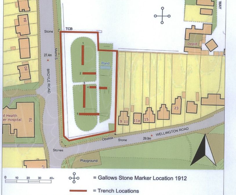
Archaeological Evaluation at Lower Graylingwell, Chichester
Archaeological and Historical Background 2.1.1 An Archaeological Desk-based Assessment was produced for the site in 2014 (AMEC 2015), and a summary of the key findings are reproduced below. 2.1.2 A small Palaeolithic handaxe was found in an evaluation 150m east of the site. There are no records of Mesolithic finds within 500m of the site. 2.1.3 Early Neolithic pits containing pottery and flintwork were found at Baxendale Avenue some 150m south of the site, and four small pits, one containing later Neolithic pottery, during evaluation a


