in 1876 was needed to authorise compulsory purchase of land for the track. The tender to build and manage the line from Thomas Oliver of Horsham was accepted by the Board of the London, Brighton and South Coast Railway in July 1878, and Robert Dendy was paid £1,374.10s in November 1879 for the track bed across Warren Farm.
The line eventually opened for a full three-class passenger service from Chichester to Pulborough via Midhurst on 11 July 1881. Unfortunately, the line could not compete with the motor car and the passenger service ended in 1935. A long siding of over half a mile on the downside south of Lavant Station was opened in 1913. It ran under the Lavant Road and The Drive to the newly opened gravel pits on the Stride Estate, and was still in operation in 1947. A foreshortened line serviced the Lavant sugar beet industry until 1969, and the Lavant gravel beds from 1971 to 1991 when it closed for good and the line lifted. The track bed became the Centurion Way, a tarmac path for pedestrians and cyclists.
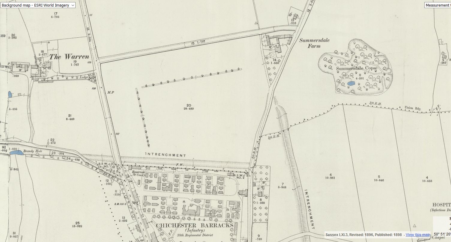
In March 1901 the Bognor Observer reported hearsay of an application to the railway company for a station to be built at the Brandy Hole Bridge to serve Stride’s residential development in Summersdale. The railway company did not approve the proposal and no more was heard of it. The same edition also suggested a penny bus service was about to start between the Chichester railway station and Summersdale, where the development of the estate was said to be progressing well. The area was described as ‘A dry and healthy location, with gas and water laid on, and rates very low.’ Strides offered special terms by which the house became the absolute and unencumbered property of the purchaser after payment of an ordinary rental for 20 years.
Borehole drilling is a technique that allows you to access underground water sources by creating a deep and narrow hole in the ground. In this blog post, we will explain what borehole drilling is, how it works, and what are its benefits and challenges.
There is rumoured to be a tunnel from the white horse to the buttery and then from the buttery to the cathedral.
Regarding a tunnel from the crypt to the cathedral. Apparently Keats while upstairs being "entertained" watched the monks lock the gate to the cathedral. Now did he have xray specs on ??? That''s the pic of the guy gesturing towards the shelves is where the door way used to be
Between The Drive’s western and southern ends, Charles Stride built a private estate in c.1905 which included a nine hole golf course designed by James Braid, a lodge (Uplands), and a mansion (Woodland Place) with tree-lined grounds which, as Rew Lane, was developed in the late 1950s. The golf course was too close to the Goodwood course to be a commercial success and it was given up for gravel extraction immediately prior to the first World War, with a mineral branch line connected later to the Chichester-Midhurst railway. His golf course and pavilion is mentioned in https://golfsmissinglinks.co.uk/index.php/england/south-east/sussex/851-sus-summersdale-golf-club-chichester
From trying to locate the areas marked on the old maps as smugglers or roman caves at the approc following locations. Our team tried to take photos as best we could.
su 85228 06608 50.8527, -0.7906 su 85255 06596 50.8526, -0.7902 su 85249 06577 50.8524, -0.7903 su 85248 06565 50.8523, -0.7903 su 85329 06661 50.8532, -0.7892 su 85359 06657 50.8531, -0.7887
Archaeological Evaluation at Lower Graylingwell, Chichester
Archaeological and Historical Background 2.1.1 An Archaeological Desk-based Assessment was produced for the site in 2014 (AMEC 2015), and a summary of the key findings are reproduced below. 2.1.2 A small Palaeolithic handaxe was found in an evaluation 150m east of the site. There are no records of Mesolithic finds within 500m of the site. 2.1.3 Early Neolithic pits containing pottery and flintwork were found at Baxendale Avenue some 150m south of the site, and four small pits, one containing later Neolithic pottery, during evaluation a
Maureen Williams, 82, of Westgate, recalled a school trip into the rumoured tunnels under Chichester when she was at Chichester High School for Girls.
She estimates she was in her early teens at the time and said she chose to share her memories after reading about the search for evidence in this newspaper.', '
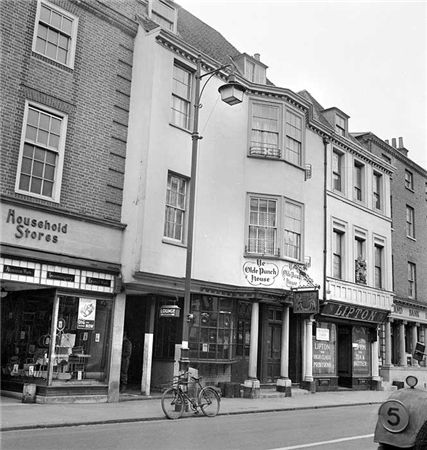
ON THE south side of East Street, close to the Market Cross, lies number 92 which up until fairly recently was The Royal Arms public house (also known as Ye Olde Punch House).
Although the façade dates to the Georgian era, the building is of a timber-framed construction said to date from the 16th century.
Much of the original building survives including highly decorated plaster ceilings displaying the Tudor Rose and fleur-de-lis.
It was once a private town house belonging to the Lumley family of Stansted.


