Archaeology

The archaeological features of Summersdale reflect the history of Chichester
as a settlement in Roman times and earlier. The main features which fall
inside this area include several stretches of the Chichester Entrenchments, a
series of linear earthworks with ramparts and single ditches, which stretch
along the coastal plain of West Sussex. Other earthworks or entrenchments
nearby show each stretch to be part of a large defensive complex thought by
some to date from Roman times, but at Devil’s Dyke to the north west they
appear to have been constructed in the Late Iron Age between 100BC and
the Roman invasion of 43AD, but conclusive evidence is lacking.

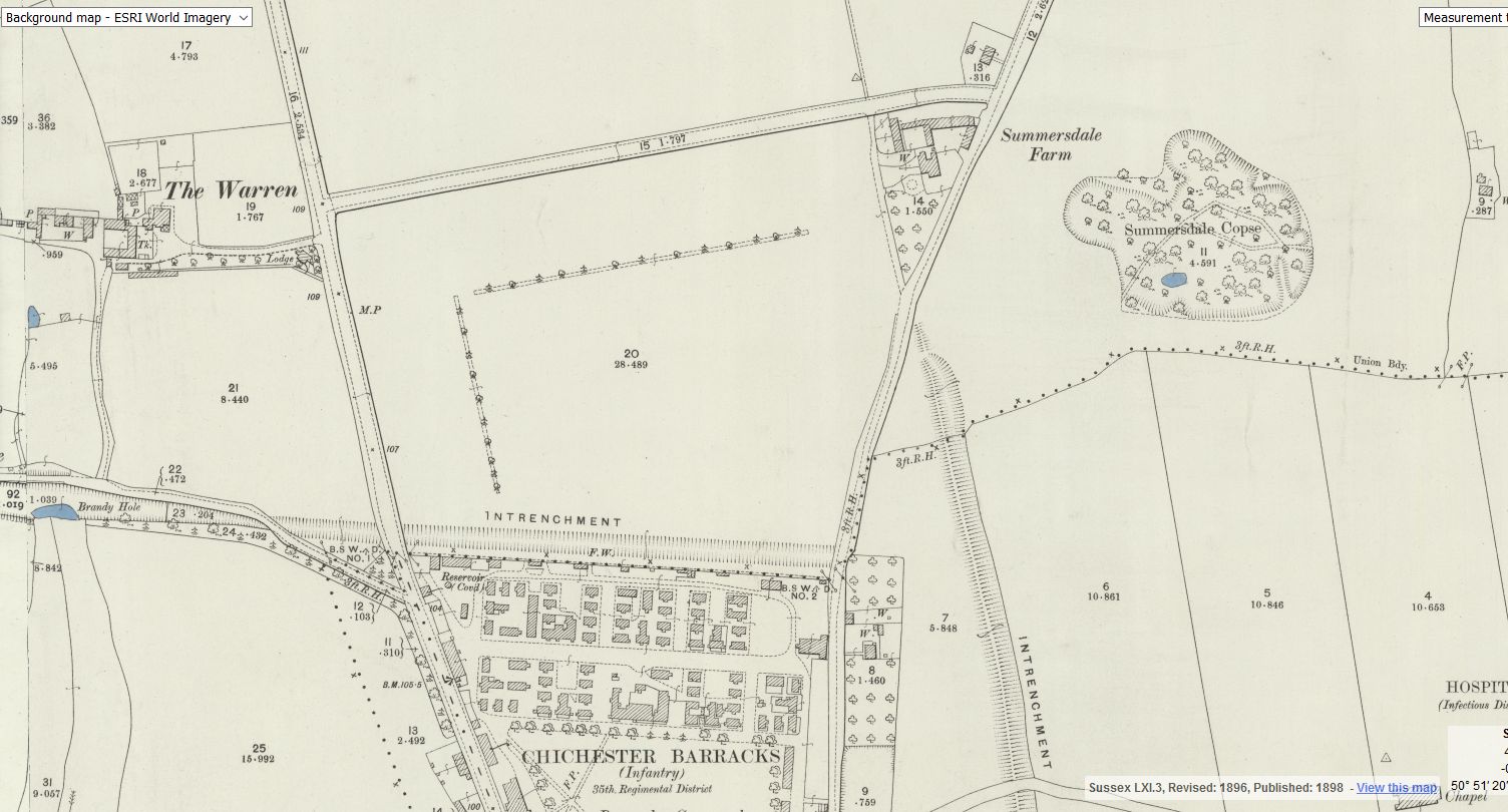
Notable examples in Summersdale can be seen in Brandy Hole Copse and a
north-south stretch running through and beyond the grounds of
Graylingwell, both of which are Scheduled Monuments.

Analysis of historic maps shows that the principal alignment of the built
landscape and indeed the Summersdale Estate is derived from the extended
north-south and east-west alignments of the Iron Age dykes across the
area, and subsequent field patterns.

The main Roman road north from Chichester to Silchester in Hampshire runs
through Summersdale along the western boundaries of the properties which
front onto the west side of Broyle Road, although the line is not absolutely
definite. Possible side ditches of the road have been noted in several places.

In Gardiner’s map of 1772, Warren Farm was crossed diagonally SE to NW
by a track which entered a few yards west of the junction of Brandy Hole
Lane and the Lavant Road, across Mid-Lavant Common to Devil’s Dyke. The
1977 1/1250 OS map attributed the track to Roman origins, but trial
trenching in 1987 by the CDC Archaeological Unit found only gravel and no
other features. The probability is that the Roman road tracked the direction
of the nearest line feature, the entrenchment to the east of it, thereby
adding credence to the earthworks originating in the Iron Age.

Description of the Area
Overview

Charles Stride created the historic elements of Summersdale in the late
1890s with the Summersdale Estate of just four new roads — The Avenue,
Highland Road, The Broadway, and Summersdale Road. The Lavant Road
bordered his land to the west, The Drive bordered his land to the north.
Development along all of these roads began at much the same time, in
the very early 1900s. Until the middle of the 20”" Century they were little
more than gravel tracks, but most were tree-lined.

The Avenue linked Summersdale Farm with Lavant Road and Warren Farm
to the west. Summersdale Road ran north/south, linking the Barracks and
Graylingwell Hospital with The Broadway, Highland Road and The Avenue.
At its northern end, the road became The Drive, encircling the estate and
joining the Lavant Road at the northern entrance to the City (see map of
the area).

Brandy Hole Lane forms a very important graded edge to the City. It was
the southern boundary of Warren Farm, and existed as a tree-lined
country lane before the creation of the Summersdale Estate. It is semi-
rural in nature and appearance, with development along its northern edge
starting in the 1920s. Rew Lane, to the north of The Drive, was developed
in the grounds of Woodland Place in the 1950s.

The northern entrance to the City along the Lavant Road is an important
introduction to the City and its Conservation Area, a fine first impression
and a significant contribution to sense of place of both Summersdale and
the City as a whole. The urban matrix along the road is one of rural to
urban transition, with a denser morphology as one moves towards the
City.

The NE Chichester Development Brief recognised Summersdale as an
important green link and gateway into the City from north of the Downs.
It offers an attractive and uncluttered route from Lavant to the City
centre. It is a place with its own identity, yet within walking distance of
the centre.

Random articles of interest

65 East Street

DD
I worked at 65 East Street when it was ''Hammick''s Bookshop'' (now Specsavers). We had a trapdoor in the middle of the floor that led down to a tunnel-shaped cellar that seemed to extend through the front of the shop and under the pavement outside. I didn''t see any evidence of it ever having joined another tunnel and imagine that perhaps there was once an opening in the pavement for deliveries.

\r\n


The Punch house

punch house pub

ON THE south side of East Street, close to the Market Cross, lies number 92 which up until fairly recently was The Royal Arms public house (also known as Ye Olde Punch House).

Although the façade dates to the Georgian era, the building is of a timber-framed construction said to date from the 16th century.

 Much of the original building survives including highly decorated plaster ceilings displaying the Tudor Rose and fleur-de-lis.

 It was once a private town house belonging to the Lumley family of Stansted.

Read more: The Punch house

Archaeological Evaluation at Lower Graylingwell, Chichester

Archaeological and Historical Background
2.1.1 An Archaeological Desk-based Assessment was produced for the site in 2014 (AMEC 2015),
and a summary of the key findings are reproduced below.
2.1.2 A small Palaeolithic handaxe was found in an evaluation 150m east of the site. There are no
records of Mesolithic finds within 500m of the site.
2.1.3 Early Neolithic pits containing pottery and flintwork were found at Baxendale Avenue some 150m
south of the site, and four small pits, one containing later Neolithic pottery, during evaluation a

Read more: Archaeological Evaluation at Lower Graylingwell, Chichester

27 East street

MB
My mum worked 27 east street and when it flooded in the 90s they found a big cellar and you could look down into an area which was like a tunnel

An Archaeological Evaluation at Roussillon Barracks

An Archaeological Evaluation atRoussillon Barracks Chichester, West Sussex


Planning Reference No: CC/10/03490/FUL Phases 1a & 1b Project No: 4861 Site Code: RBC 11ASE Report No: 2011128 OASIS id: archaeol6-102472 By Diccon HartWith contributions by Sarah Porteus Illustrations by Fiona GriffinJune 2011


summersdale golf course and mr Stride

Between The Drive’s western and southern ends, Charles Stride built a private estate in c.1905 which included a nine hole golf course designed by James Braid, a lodge (Uplands), and a mansion (Woodland Place) with tree-lined grounds which, as Rew Lane, was developed in the late 1950s. The golf course was too close to the Goodwood course to be a commercial success and it was given up for gravel extraction immediately prior to the first World War, with a mineral branch line connected later to the Chichester-Midhurst railway.
His golf course and pavilion is mentioned in https://golfsmissinglinks.co.uk/index.php/england/south-east/sussex/851-sus-summersdale-golf-club-chichester

The club was founded in 1904.

Read more: summersdale golf course and mr Stride

building a cellar

cellar image

Historically, to build a house with a simple cellar you would dig out the ground to a depth of around 6ft, the cellar walls would have been constructed with a lining of stone or brick and with a drain for water within the cellar. The floors would have been built up on crushed stone or sand to provide a level surface and paved, usually with flags. Brick paving became more common in later periods.

Read more: building a cellar

Russilon Barracks

The Chichester SMR holds information for 48 sites, whilst the National Monuments Record
Centre holds details of a further 16 sites within the study area. An additional four sites were
located through analysis of historic mapping and during the course of the walkover survey and
one from aerial photographs. Full site descriptions and locations can be seen in Appendix B.
Within the report, the bracketed numbers after site descriptions relate to those allocated to
individual sites in Appendix B and on Figure 2.

Read more: Russilon Barracks

Architects concept plan - Graylingwell aerial designers dream

architects concept plan - graylingwell aerial designers dream. This vision is far from reality and some say even mention the trades description act.

Read more: Architects concept plan - Graylingwell aerial designers dream

More In Articles