The Chichester SMR holds information for 48 sites, whilst the National Monuments Record
Centre holds details of a further 16 sites within the study area. An additional four sites were
located through analysis of historic mapping and during the course of the walkover survey and
one from aerial photographs. Full site descriptions and locations can be seen in Appendix B.
Within the report, the bracketed numbers after site descriptions relate to those allocated to
individual sites in Appendix B and on Figure 2.
Only one Scheduled Monument is located within the study area. This is the Chichester
defensive entrenchments dating to the Iron Age period (1).
There are eight listed buildings within the study area. Two buildings, the Chichester Festival
Theatre and Royal and West Sussex Hospital, are designated Grade II*. The others all
designated Grade II listed.
There are two Conservation Area within the study area. The Chichester Conservation Area lies
along the southern boundary of the site and the Grayingwell Hospital Conservation Area is
positioned directly to the east of the barracks. The Graylingwell Hospital also falls within a
Grade II Registered Park. The boundaries of these features can be seen on Figure 2.
There are no World Heritage Sites or Registered Battlefields within the study area.
Prehistoric (to 43 AD)
Very few previously recorded sites dating to the prehistoric period are known within the study
area. One Palaeolithic (to c. 10,000 BC) hand axe (19) was recovered from a garden on
Brandyhole Lane. No further dated evidence is recorded until the Neolithic period (c. 3500BC to
2600 BC). This comprises the find spot of a stone axe (12). No artefacts from the intermediate
Mesolithic period (c. 10,000 BC to 3500BC) have been recovered.
The first true indication of settlement in this area dates to the Bronze Age (c. 2800BC – 800BC).
Four previously recorded sites have been recorded within the study area. Possible evidence of
settlement was found just to the north of Graylingwell Hospital (57) as well as the remains of six
cremation burials (51) dating to the middle Bronze Age. Further evidence to support this has
been found in the form of a Bronze palstave1 (13) and a barbed and tanged arrow head (39)
recovered from a garden.
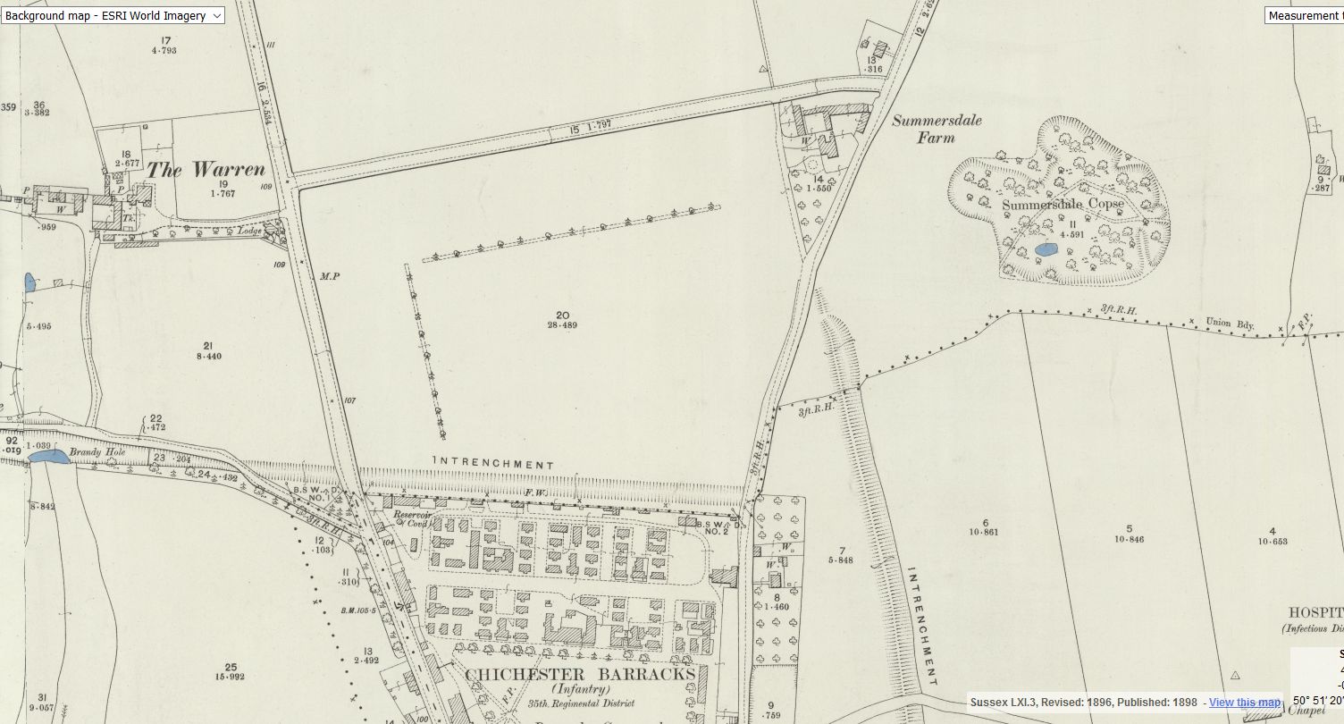
The first major features in the area date to the Iron Age (800BC – 43AD). The Scheduled
Monument within the study area is the Chichester Dykes or entrenchments (1). This defensive
system of ditches date to later in the Iron Age period which was a time of unrest between the
tribes of England. One section of these entrenchments are believed to follow the alignment of
The Broadway, the road which borders the development site to the north.
Other features from the Iron Age have also been identified within the study area. During works
at Graylingwell Hospital excavations identified sections of the entrenchments. Just within its line
an enclosure which may indicate the position of a settlement (52) was identified while two
earthenware pots with cremated bones were recovered from just outside the entrenchment
(43). Shards of pottery from this period have also been recovered from an excavation at the
rear of Cawley’s Almshouses (23).
No features dating to the prehistoric period have been identified within the site boundary.
Roman (43AD– 450 AD)
One of the key periods within this area is the Roman occupation. When the Romans came to
this area the local ruling tribe co-operated rather than resisted, which allowed them to retain
1 A bronze axehead of middle or late Bronze Age date in which the side flanges and the
bar/stop on both faces are connected, forming a single hafting aid.(Source:
http://thesaurus.english-heritage.org.uk/)
3 Results
Faber Maunsell Roussillon Barracks, Chichester 10
some control in the area. The Romans built a fort where the modern city now stands and when
they moved on the local tribe took control and developed it into a town, Noviomagus. In the 2nd
century a defensive ditch was placed around the town with a wooden palisade. Later these
wooden defences were replaced with a stone wall, bastions and towers
(http://www.localhistories.org/chichester.html). Chichester had many of the recognisable
elements of many Roman towns across Europe including an amphitheatre, public baths and
temples.
The proposed development site falls outside of the defensive walls of the Roman town.
However, evidence form the study area suggests that occupation was not confined to within
these walls. There are five recorded sites within the study area with evidence of Roman
settlement (20, 24, 44, 53, 55). This evidence includes pottery, tile and masonry and one site
excavated in 2001 identified remains of a timber cill-beamed building (24). Evidence such as
Roman water pipes (25), ditches (25, 58), a possible kiln (64) and several coins (36, 38, 46, 47)
help to illustrate the level of settlement in this area.
Two sites show the burial practises dating to this period. The St Pancras Roman Cemetery (20)
lies in the southern section of the study area just outside the east gate. The excavation at
Cawley’s Almshouses in 1998 also identified two urns containing burials (42) also dating to the
Roman period.
The alignments of two roads dating to this period are also believed to cross the study area. The
first runs 39 miles from Chichester to Silchester (10) and was identified from aerial photography
by the Ordnance Survey (Margary 1967, 78). The road left Chichester at the north gate and ran
north-westerly through the study area to the west of Broyle Road. Sections of this road have
been identified at different times during excavation. The second suggests that the line of St
Paul’s Road (63) running north-west out of the city may also be a Roman road however there is
less evidence to support this.
No features from the Roman period have been identified within the site boundary.
Early Medieval (450 AD – c. 1066)
There are two site of early medieval date recorded within the study area. The first is the site of
Chichester Priory (11) located to the south of the study area. The Priory, which possibly had a
minster and double house, was founded c. 956 and a Benedictine nunnery was later added
prior to 1066. The Priory was dissolved in 1075. The only other evidence dating to this period
was an early Saxon spearhead (34) found in a garden of a house just to the north of the
proposed development area.
No features from the early medieval period have been identified within the site boundary.
Medieval (c.1066 – 1500)
There are two known and one possible additional site of medieval date recorded within the
study area. This period was also important for the development site itself. One road, the
Chichester to Hindhead trackway (54), ran to the east of the development sites and a ditch was
identified during an archaeological excavation.
The development site itself is documented as forming part of a deer park during the medieval
period. The place name ‘Broyle’ refers to an area of forest enclosed by walls or ditches and
possibly stocked with animals for hunting. The land was owned by the king but was granted to
the Bishop of Chichester by Henry II. The Manor Broyle remained in the church ownership and
appears to have remained as moor land until it was purchased for the purpose of developing a
barracks on the site in the 18th century.
Post-Medieval (c.1500 AD – 1900 AD)
Chichester continued to expand during the post-medieval period as the population continued to
increase. A number of recorded sites within the study area relate to the development of the
town and the growth of farming practises in the wider area. The Plan of the Manor of Broyle
from 1772 and Glot’s survey from around the same time (see Figure 3) shows that much of the
land to the north of Chichester had been divided into field systems. The area named as ‘The
Broile’ is defined by the same boundaries as the proposed development site and is shown on
the map as open moorland, with one farm with a defined field and formal garden at the southern
end of the site. The farm is believed to be later subdivided into 29 and 31 Wellington Road
Faber Maunsell Roussillon Barracks, Chichester 11
which are now Grade II listed buildings. Two windmills (35, 37) and two wells (18, 41) are
recorded within the study area which may relate to the farming practices being undertaken.
The two maps discussed above, and subsequent editions of the Ordnance Survey maps, also
make reference to the town gallows and an obelisk being located on the southern section of the
development site. A commemorative stone once stood on the site marking the location of the
gallows and recounting the story of the “Halkhurst Gang”, a member of which is recorded to
have been buried in the field adjacent to the gallows. This stone and obelisk were relocated in
later years when the barracks became a secure site. The stone with information about the gang
now stands outside of the wall on Broyle Road (see Photograph 1) and the obelisk is positioned
adjacent to the southern gate on Wellington Street (see Photograph 2). The inscription on the
stone can be seen in Appendix C (Keating. 1979. 59).
The 1846 Tithe Map of St Peter the Great records the two key areas of the development site as
being owned by the Barracks Department with the field names given as “The Barracks” and
“Gallows Field”. There are no structures associated with the barracks depicted on the mapping
at this time suggesting that accommodation at this time was in the form of tents. Records show
that the land was built on between 1795 and 1813 at the cost of £76,167 on land purchased
from the Bishop of Chichester. The Hampshire Telegraph followed the stages of building on the
site in 1803 by French Prisoners of War and recorded (www.army.mod.uk):
21 Feb – Barracks occupied by the barracks master and family
1 Aug - 100 men building new cavalry Barracks on the Broil
5 Sep - Work proceeding rapidly to accommodate 1500 men
21 Nov - Nearly finished.
Numerous cavalry and infantry units were stationed at the barracks throughout the 19th century
and a plan of the barracks from 1859 (Entec, 2007) shows that much of the layout of the
barracks is in place by this time with the northern section of the site occupied by small
structures for accommodation, the parade ground laid out and a hospital present in the south
east corner of the site.
In 1873 the barracks became the regimental station for the Royal Sussex Regiment. They had
been formed in 1701 and had served in a number of campaigns including the defeat of the
French Royal Roussillon Regiment in 1759 which would go on to lend its name to the barracks
in 1958.
The next major stage of development was in 1875 when some of the wooden structures were
replaced by brick buildings including the Keep and the Chapel and the site was enclosed by the
flint and brick wall which is extant (see section 3.2 below).The Ordnance Survey map of 1875
(see figure 4) shows the layout of the barracks, the fact that the surrounding area was still
undeveloped and that the northern boundary of the site was defined by a section of the Iron
Age entrenchments where The Broadway now runs. The hospital is clearly marked on the map
as a small grouping of buildings with a driveway. Several buildings are located along Broyle
Road including canteen, guardhouse, stores and a magazine.
A number of buildings that may be expected on the outskirts of a town are within the study
areas and demonstrate how Chichester grew in this period. A lime kiln (41) is located along
Broyle Road at a safe distance from the walls. Establishments such as the work house (16), the
Graylingwell Lunatic Asylum (17) and the hospital were all in easy reach of the city but out of
public view.
Most of the listed buildings within the study area date to the post-medieval period. Only three of
the buildings, two on Wellington Road (7 and 8) and a small row of terrace houses on Broyle
Road are adjacent to the proposed development site.
Modern (1900 AD - Present)
Further development of the site was undertaken in the 1930s which included the construction of
the Sandhurst Block and some of the accommodation to the north of the parade ground. The
Royal Sussex Regiment were merged with the Home Counties Brigade in 1960 and moved to
Canterbury. At this time the barracks were taken over by the Royal Military Police and another
stage of building work was undertaken. An Officer’s Mess, Sergeant’s Mess, training facilities
Faber Maunsell Roussillon Barracks, Chichester 12
and an assault course, some of which are depicted on the 1963 OS map (see figure 5), were
constructed.
Many of the previously recorded sites dating to this period are also linked to the military.
Several examples of World War II defences are known in the area. Tank traps and ditches (21,
61 and 62) as well as concrete blocks (28, 31 and 41) were positioned to protect approaches to
the city.
One listed building, the Grade II* Chichester Festival Theatre also dates to the modern period.
Whilst the proposed development site remained under military control the rest of the study area
was gradually incorporated into the urban development of Chichester, with housing surrounding
the site to the west and north and open parkland being retained to the south and east.
The areas directly to the east and south of the proposed development site fall within the
Chichester and Graylingwell Conservation Areas. The Conservation Areas have been
designated due to their special architectural or historic interest which requires preservation or
enhancement (www.chichester.gov.uk).
Unknown Date
There are two sites of unknown date within the study area. In two locations (29 and 32) layers
of gravel have been noted during drainage and construction works. The exact nature of these
layers in unknown


