Random articles of interest
st johns church
About 50 years ago in the vestry of St. John’s Church In Chichester a flag stone was taken up by some teenagers and a tunnel was revealed. Apparently it runs along under St Johns Street in a south / north direction
.MS
tunnels underneath Hansford Menswear
A number of those readers remembered a story about tunnels underneath Hansford Menswear, also in South Street, so we spoke the shop's owner to find out more Matthew Hansford described a blocked-off passage in cellar of the shop, which he believes may have led to the cathedral
.
An Archaeological Evaluation at Roussillon Barracks
An Archaeological Evaluation atRoussillon Barracks Chichester, West Sussex
Planning Reference No: CC/10/03490/FUL Phases 1a & 1b Project No: 4861 Site Code: RBC 11ASE Report No: 2011128 OASIS id: archaeol6-102472 By Diccon HartWith contributions by Sarah Porteus Illustrations by Fiona GriffinJune 2011
White Horse / Prezzo
Max T
I recall that there is a short length of tunnel (blocked off at both ends) under the old White Horse pub in South St. (now Prezzo restaurant, since 2005). Story in the pub was that it was part of a tunnel running from the Cathedral up to the Guildhall in Priory Park. Although the tunnel is there, I was never sure of its true purpose or the truth of its start / finish. Thought that it was worth mentioning it on here though.
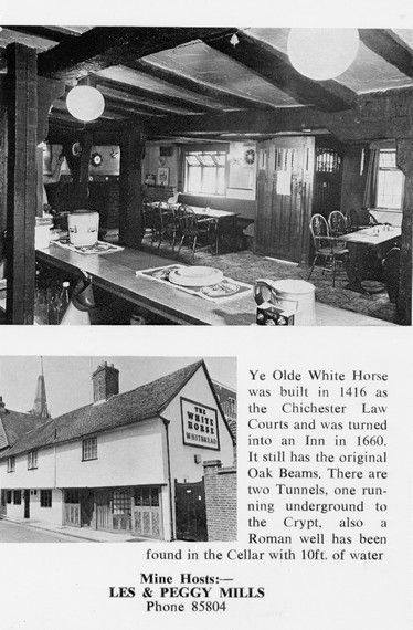
It was under the Crypt and right next to the cathedral

Maureen Williams, 82, of Westgate, recalled a school trip into the rumoured tunnels under Chichester when she was at Chichester High School for Girls.
She estimates she was in her early teens at the time and said she chose to share her memories after reading about the search for evidence in this newspaper.
Read more: It was under the Crypt and right next to the cathedral
Chichester Culverts
We do not suggest going into the culverts.
These are not classified as tunnels and can be dangerous
video of culverts/storm drains/winterbourne route
Map of Chichester showing Rivers
www.streetmap.co.uk\\/map.srf?x=486359&y=104953&z=120&sv=chichester&st=3&tl=Map%20of%20Chichester%2C%20West%20Sussex%20[City%2FLarge%20Town]&searchp=ids.srf&mapp=map.srf&fbclid=IwAR2IV7YUeQ8u_GBTHRE24fSpUvVRwu5CpZxdPt1fs_injtw73WMxXbTQ25s
Summersdale Neighbourhood Character Appraisal
'
Summersdale is an attractive area in the north of Chichester. Spacious
and leafy, the character of the area is now under threat with many houses
on large plots at risk of demolition and re-development. It is an historic
suburb with high quality architecture in street scenes that are worthy of
enlightened protection.
building a cellar

Historically, to build a house with a simple cellar you would dig out the ground to a depth of around 6ft, the cellar walls would have been constructed with a lining of stone or brick and with a drain for water within the cellar. The floors would have been built up on crushed stone or sand to provide a level surface and paved, usually with flags. Brick paving became more common in later periods.
65 East Street
DD
I worked at 65 East Street when it was ''Hammick''s Bookshop'' (now Specsavers). We had a trapdoor in the middle of the floor that led down to a tunnel-shaped cellar that seemed to extend through the front of the shop and under the pavement outside. I didn''t see any evidence of it ever having joined another tunnel and imagine that perhaps there was once an opening in the pavement for deliveries.

First, there are no maps in the presentation to hidden tunnels , all information is in the public do...

Are you curious about the tunnels in Chichester? If you are, you are not alone. Many people have won...

Borehole drilling is a technique that allows you to access underground water sources by creating a d...

AArc141/14/EVAL Roussillon Park, Broyle Road, Chichester, West Sussex, PO19 BBL
Sporadic finds repr...

A number of those readers remembered a story about tunnels underneath Hansford Menswear, also in Sou...

Maureen Williams, 82, of Westgate, recalled a school trip into the rumoured tunnels under Chichester...

An introduction to researching properties
{youtube}R3F2rWapKzw{/youtube}


architects concept plan - graylingwell aerial designers dream. This vision is far from reality and s...

Maureen Williams, 82, of Westgate, recalled a school trip into the rumoured tunnels under Chichester...
More In Articles


