Between The Drive’s western and southern ends, Charles Stride built a private estate in c.1905 which included a nine hole golf course designed by James Braid, a lodge (Uplands), and a mansion (Woodland Place) with tree-lined grounds which, as Rew Lane, was developed in the late 1950s. The golf course was too close to the Goodwood course to be a commercial success and it was given up for gravel extraction immediately prior to the first World War, with a mineral branch line connected later to the Chichester-Midhurst railway. His golf course and pavilion is mentioned in https://golfsmissinglinks.co.uk/index.php/england/south-east/sussex/851-sus-summersdale-golf-club-chichester
The club was founded in 1904.
Summersdale professionals; Reginald Gray, 1904-1906; Arthur G Gray/ H Bowden 1907/8; W Barfoot, 1908-1911; G Chalk 1911-1913, (also early 1920s); G Clark, 1915-1926. In 1904/5 the secretary was F Stride, East Street, Chichester, the captain was M F Mieville, and the professional Reginald Gray (finished 45th in the 1904 Open Championship). Course records were; professional, R Gray 41; amateur, M F Mieville 43. The nine-hole course was laid out by James Braid in the summer of 1904. The course measured 3,370 yards with two holes over 500, and three over 400 yards with a bogey score of 43. There was no entry fee and subs were £2/2s; ladies £1/1s. There was a membership of 100 which was steadily increasing, and there was a “comfortable clubhouse.” Visitors’ on introduction, free for two days, afterwards 2/6 a day, 5/- a week and 15/- a month. Railway stations at Lavant, one mile, and Chichester one and a quarter miles.
Random articles of interest
It was under the Crypt and right next to the cathedral
Maureen Williams, 82, of Westgate, recalled a school trip into the rumoured tunnels under Chichester when she was at Chichester High School for Girls.
She estimates she was in her early teens at the time and said she chose to share her memories after reading about the search for evidence in this newspaper.
Are you curious about the tunnels in Chichester? If you are, you are not alone. Many people have wondered about the existence and purpose of these underground passages that are said to run under the city. Some claim they have seen them, others have heard stories about them, but what is the truth behind the mystery?
In this blog post, I will try to shed some light on the tunnels in Chichester, based on some web searches and historical sources. I will also share some of the rumours and legends that surround them, and invite you to share your own experiences or opinions in the comments section.
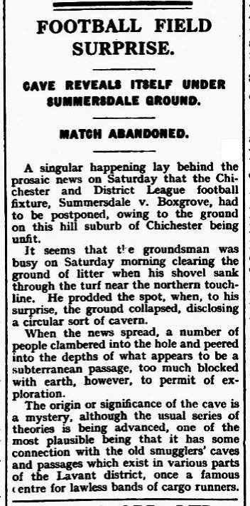
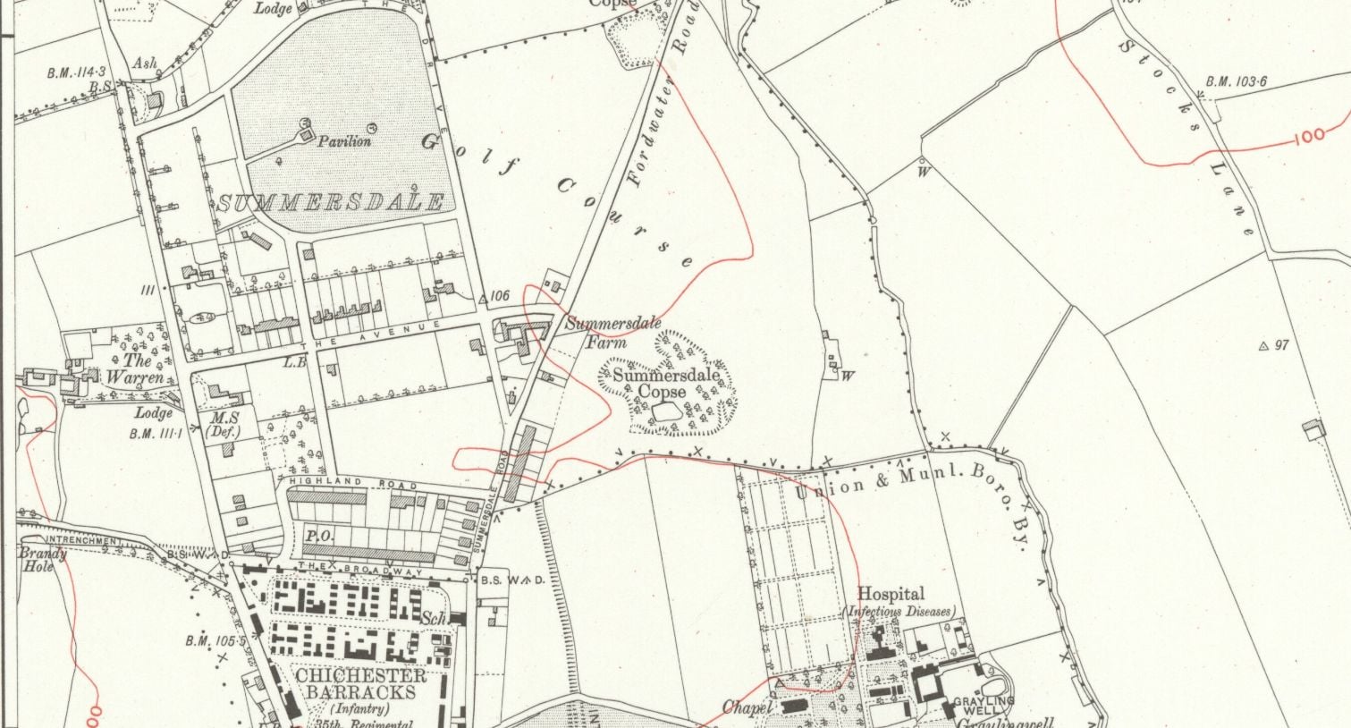
summeerdale football ,I have an update on the old newspaper article relating to Summersdale and the tunnel found under a football pitch. I sent an email to the Summersdale Residents Association, and they were extremely helpful with one of the members being able to identify a location for the site of the pitch. Looking at some old maps and combining the documents from Liam Mandville regarding subsidence etc. the area between The Avenue and Highland Road (on the Eastern side), does fit well as to the location. Many of the properties built on this site have substantial gardens so there may still be something to find that could explain what was found by the groundkeeper all those years ago? ,5f6f8e5fb6881-116345275_10157348686446892_326855352233187857_n.jpg,5f6f8e5fb7b45-116168775_10157348685396892_1033817068655264665_n.jpg
One of the most common questions I’m asked about Peterborough’s history is whether there are any tunnels under the city. Local legends say that there is a tunnel stretching from the Cathedral to Monk’s Cave at Longthorpe. Similar tunnels are alleged to stretch from the Cathedral to the abbeys at Thorney or Crowland.
These are familiar myths in many historic cities across the UK, mostly urban legends based on half remembrances of sewers, cellars or crawlspaces, coupled with wishful thinking and rumour.
The Chichester SMR holds information for 48 sites, whilst the National Monuments Record Centre holds details of a further 16 sites within the study area. An additional four sites were located through analysis of historic mapping and during the course of the walkover survey and one from aerial photographs. Full site descriptions and locations can be seen in Appendix B. Within the report, the bracketed numbers after site descriptions relate to those allocated to individual sites in Appendix B and on Figure 2.
Historically, to build a house with a simple cellar you would dig out the ground to a depth of around 6ft, the cellar walls would have been constructed with a lining of stone or brick and with a drain for water within the cellar. The floors would have been built up on crushed stone or sand to provide a level surface and paved, usually with flags. Brick paving became more common in later periods.
Maureen Williams, 82, of Westgate, recalled a school trip into the rumoured tunnels under Chichester when she was at Chichester High School for Girls.
She estimates she was in her early teens at the time and said she chose to share her memories after reading about the search for evidence in this newspaper.', '


