punch house

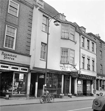
ON THE south side of East Street, close to the Market Cross, lies number 92 which up until fairly recently was The Royal Arms public house (also known as Ye Olde Punch House).

Although the façade dates to the Georgian era, the building is of a timber-framed construction said to date from the 16th century.

 Much of the original building survives including highly decorated plaster ceilings displaying the Tudor Rose and fleur-de-lis.

 It was once a private town house belonging to the Lumley family of Stansted.

 John Lord Lumley is believed to have entertained Queen Elizabeth I there in 1591, having made elaborate preparations for the visit.


 The Royal Arms is most famous for its Milk Punch, which is where it got its alternative name ‘The Old Punch House’.


 The Punch produced here is said to have been one of Queen Victoria’s favourite tipples.


 Before she and Prince Albert found Osbourne House on the Isle of Wight, and while looking about for a suitable alternative to the Brighton Pavilion, they often stayed in Chichester.


 As a drink, it was made with milk to which lemon juice, sugar and rum was added then allowed to mature for up to two years.


 Later in the 19th century, the property came into the ownership of G S Constable Ltd, brewers in Littlehampton and Arundel.


 They continued the tradition of producing Milk Punch until the outbreak of the First World War.


 Production at this time was discontinued, mainly due to sugar being in short supply due to rationing, as well as the length of time required to allow the drink to mature.


 The Novium collections contain a bottle containing Milk Punch manufactured by G.S. Constable in the 1920s.


 There have been various landlords and owners over subsequent years.


 In 1983 the licensee was Dennis Pordage who, in 1998, made a call for longer opening hours in Chichester which would be more in keeping with those already accepted in Bognor and Littlehampton.


 In March, 2000, over 100 firefighters were required to fight a serious fire at The Royal Arms.


 It took a total of four hours to bring the fire under control.


 Arson was first suspected but investigations concluded it was a carelessly discarded cigarette butt.


 The fire badly damaged the roof and second floor.


 The necessary repairs then took a couple of months longer to complete than anticipated so the pub wasn’t ready to re-open until July.


 Advice needed to be sought from English Heritage to ensure the ornate 16th century plasterwork ceiling (on the first floor) was preserved and restored although it had survived relatively unscathed.


 By 2006, the public house was owned by Alpha Investments, which decided to close the Royal Arms as a pub.


 The district council granted planning permission to convert the pub into two retail shop outlets, currently Fat Face and River Island, subject to the ceilings being protected.


By Pat Saunders, volunteer at The Novium Museum


https://chichestertunnels.group/downloads/punch.pdf


Random articles of interest

Graylingwell Heritage Project

 'Graylingwell Heritage Project', 'graylingwell-heritage-project', '

BENEATH THE WATER TOWER

The Graylingwell Heritage Project has been a community based heritage and arts programme located in Chichester, West Sussex.

The original Victorian buildings had a central boiler house with the water tower which is, after the Cathedral spire, by far the tallest building in Chichester. And if you go up to the Trundle and look down on Chichester, the only two buildings you can see are the Cathedral spire and the Graylingwell water tower.

Read more: Graylingwell Heritage Project

summersdale golf course and mr Stride

Between The Drive’s western and southern ends, Charles Stride built a private estate in c.1905 which included a nine hole golf course designed by James Braid, a lodge (Uplands), and a mansion (Woodland Place) with tree-lined grounds which, as Rew Lane, was developed in the late 1950s. The golf course was too close to the Goodwood course to be a commercial success and it was given up for gravel extraction immediately prior to the first World War, with a mineral branch line connected later to the Chichester-Midhurst railway.
His golf course and pavilion is mentioned in https://golfsmissinglinks.co.uk/index.php/england/south-east/sussex/851-sus-summersdale-golf-club-chichester

The club was founded in 1904.

Read more: summersdale golf course and mr Stride

Chichester Culverts

We do not suggest going into the culverts.
These are not classified as tunnels and can be dangerous

 video of culverts/storm drains/winterbourne route


Map of Chichester showing Rivers


www.streetmap.co.uk\\/map.srf?x=486359&y=104953&z=120&sv=chichester&st=3&tl=Map%20of%20Chichester%2C%20West%20Sussex%20[City%2FLarge%20Town]&searchp=ids.srf&mapp=map.srf&fbclid=IwAR2IV7YUeQ8u_GBTHRE24fSpUvVRwu5CpZxdPt1fs_injtw73WMxXbTQ25s

building a cellar

cellar image

Historically, to build a house with a simple cellar you would dig out the ground to a depth of around 6ft, the cellar walls would have been constructed with a lining of stone or brick and with a drain for water within the cellar. The floors would have been built up on crushed stone or sand to provide a level surface and paved, usually with flags. Brick paving became more common in later periods.

Read more: building a cellar

st johns church

About 50 years ago in the vestry of St. John’s Church In Chichester a flag stone was taken up by some teenagers and a tunnel was revealed. Apparently it runs along under St Johns Street in a south / north direction

.MS

Read more: st johns church

Underneath Hansford Menswear

hansford menswear shop front

A number of those readers remembered a story about tunnels underneath Hansford Menswear, also in South Street, so we spoke the shop''s owner to find out more.
Matthew Hansford described a blocked-off passage in cellar of the shop, which he believes may have led to the cathedral

Read more: Underneath Hansford Menswear

researching properties using the council planning system

An introduction to researching properties

Doline – Chichester To Westbourne

Doline  – Chichester To Westbourne

doline

 Brandy Hole Lane, East Broyle Copse area in the northwest part of Chichester. A well-developed doline line extends east-west across the area to the north of Brandy Hole Lane, along the underlying Chalk-Reading Beds boundary.


The Environment Agency has made 1m-resolution LIDAR imagery coverage for large areas of England and Wales freely available on the internet under Open Government Licence (www.lidarfinder.com).

Read more: Doline – Chichester To Westbourne

whyke lodge


More In Articles