Random articles of interest
peterborough tunnels
One of the most common questions I’m asked about Peterborough’s history is whether there are any tunnels under the city. Local legends say that there is a tunnel stretching from the Cathedral to Monk’s Cave at Longthorpe. Similar tunnels are alleged to stretch from the Cathedral to the abbeys at Thorney or Crowland.
These are familiar myths in many historic cities across the UK, mostly urban legends based on half remembrances of sewers, cellars or crawlspaces, coupled with wishful thinking and rumour.
The stories of tunnels from Peterborough to
Archaeological Evaluation at Lower Graylingwell, Chichester
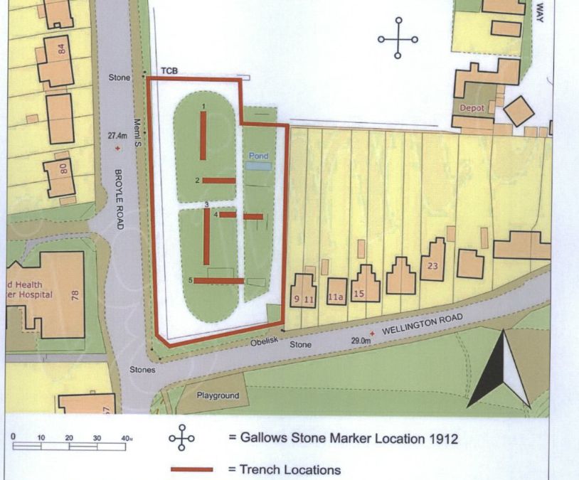
Archaeological and Historical Background
2.1.1 An Archaeological Desk-based Assessment was produced for the site in 2014 (AMEC 2015),
and a summary of the key findings are reproduced below.
2.1.2 A small Palaeolithic handaxe was found in an evaluation 150m east of the site. There are no
records of Mesolithic finds within 500m of the site.
2.1.3 Early Neolithic pits containing pottery and flintwork were found at Baxendale Avenue some 150m
south of the site, and four small pits, one containing later Neolithic pottery, during evaluation a
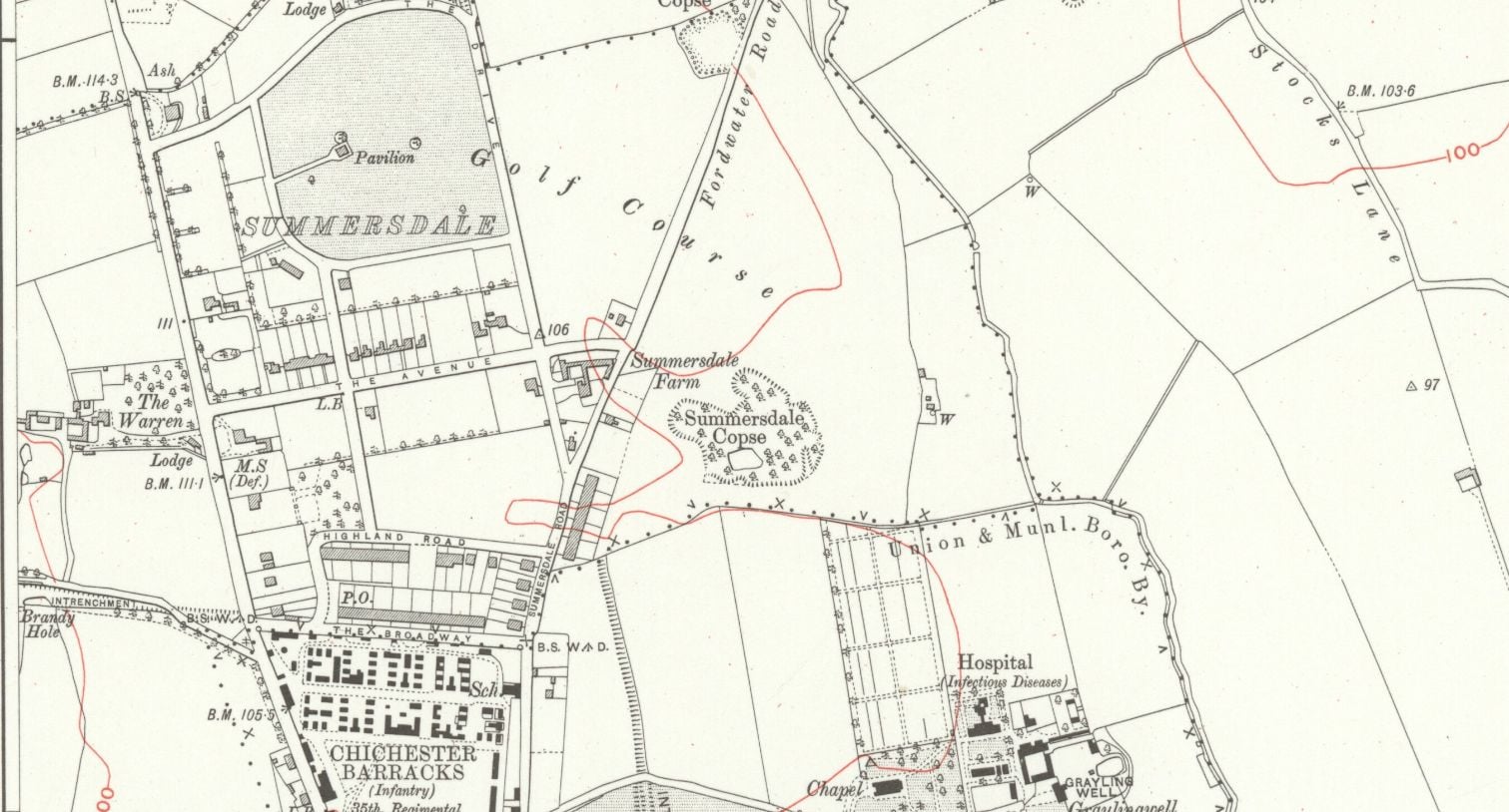
summersdale golf course and mr Stride
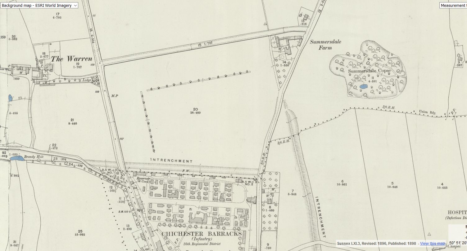
Between The Drive’s western and southern ends, Charles Stride built a private estate in c.1905 which included a nine hole golf course designed by James Braid, a lodge (Uplands), and a mansion (Woodland Place) with tree-lined grounds which, as Rew Lane, was developed in the late 1950s. The golf course was too close to the Goodwood course to be a commercial success and it was given up for gravel extraction immediately prior to the first World War, with a mineral branch line connected later to the Chichester-Midhurst railway.
His golf course and pavilion is mentioned in https://golfsmissinglinks.co.uk/index.php/england/south-east/sussex/851-sus-summersdale-golf-club-chichester
The club was founded in 1904.
whyke lodge
summeerdale football
summeerdale football ,I have an update on the old newspaper article relating to Summersdale and the tunnel found under a football pitch. I sent an email to the Summersdale Residents Association, and they were extremely helpful with one of the members being able to identify a location for the site of the pitch. Looking at some old maps and combining the documents from Liam Mandville
regarding subsidence etc. the area between The Avenue and Highland Road (on the Eastern side), does fit well as to the location. Many of the properties built on this site have substantial gardens so there may still be something to find that could explain what was found by the groundkeeper all those years ago? ,5f6f8e5fb6881-116345275_10157348686446892_326855352233187857_n.jpg,5f6f8e5fb7b45-116168775_10157348685396892_1033817068655264665_n.jpg
st johns church
About 50 years ago in the vestry of St. John’s Church In Chichester a flag stone was taken up by some teenagers and a tunnel was revealed. Apparently it runs along under St Johns Street in a south / north direction
.MS
building a cellar

Historically, to build a house with a simple cellar you would dig out the ground to a depth of around 6ft, the cellar walls would have been constructed with a lining of stone or brick and with a drain for water within the cellar. The floors would have been built up on crushed stone or sand to provide a level surface and paved, usually with flags. Brick paving became more common in later periods.
27 East street
MB
My mum worked 27 east street and when it flooded in the 90s they found a big cellar and you could look down into an area which was like a tunnel
ABSOLUTE ARCHAEOLOGY Rousillonn Barracks Evaluation

AArc141/14/EVAL Roussillon Park, Broyle Road, Chichester, West Sussex, PO19 BBL
Sporadic finds represent the early prehistoric period in the vicinity of the Project Site, with
the discovery of Palaeolithic axe in a garden on Brandy Hole Lane (c. 600m to the NW)
and a Neolithic stone axe, in the vicinity of Spitalfield Lane, over 1km to the SE (Lee 2008:
9).
Bronze Age activity has been recorded c. 500m to the east of the site, in the vicinity of
Garyiingwell Hospital, where evidence for settlement was identified along with remains of
six cremation burials (Lee 2008: 9).


